New policies classify standard canyoneering safety tools as prohibited installations.

The Coalition of American Canyoneers is filing these organizational comments with the National Park Service and the US Forest Service regarding the use of fixed anchors in Wilderness. Numbers matter and your comments can be vital to help us change these misguided policies.

Coalition of American Canyoneers Comments to the National Park Service
Coalition of American Canyoneers Comments to the U.S. Forest Service

What can […]

2024-01-27T08:21:18-08:00December 26th, 2023|Categories: Access, Education, General News|

Halls Creek Parking

The Kingdom Route/Overland Route is now open again and the parking area (WGS 84, 37.61615, -110.79873) at the trail head can be used, but only within the established boundaries laid out. Cars will be towed if not within boundaries. A few years back Glen Canyon National Recreation Area closed it, as off road parking is prohibited. Capitol Reef National Park rangers worked with Glen Canyon National Recreation Area rangers to […]

2023-05-10T12:23:43-07:00January 11th, 2023|Categories: Access, General News|

A Message to the Canyoneering Community Regarding COVID-19

Dear CAC members and friends,

The COVID-19 pandemic is unprecedented and impacts us all — in our daily lives, through our family and friends, or by the announcements and news reports coming from around the world. This is the time of year when many of us look forward to trips we have been planning for months, and the feelings of awe and gratitude we experience in our National Parks and public […]

2020-03-28T07:52:06-07:00March 28th, 2020|Categories: Access, General News, Newsletter, Safety|Tags: , , |

Capitol Reef Pilot Canyoneering Permit System

Cassidy ArchCapitol Reef National Park will begin a pilot mandatory Canyoneering Permit System starting January 1, 2020. Permits will be free of charge and require self-registration located at the Capitol Reef National Park Visitor Center or online on the park website. These permits will be required for all canyoneering and climbing activities within the park.

Capitol Reef National Park staff have observed a […]

2019-12-16T14:17:59-08:00December 16th, 2019|Categories: Access, Education, Safety|Tags: , |

Canyon Graffiti and Damage Report Form

Conservation is at the heart of the Coalition of American Canyoneers’ mission to preserve and promote access to America’s canyons. The canyons are living systems; they are the metaphoric circulatory system of the planet.

We hope to highlight any threat to our canyons and through the power of our membership take action to facilitate the repair of any damage and provide a measure […]

2019-11-14T08:43:12-08:00November 13th, 2019|Categories: Access, Conservation, Education, General News|Tags: , |

Navajo Nation Closes Access to Marble Canyon

UPDATE – Marble Canyon Closure • 9/3/19

The Navajo Nation released an update to the recent closure of access to Marble Canyon via Navajo reservation lands. The closure now only affects the access to the Tatahatso Point area.  Permits for all other areas are being issued by the Navajo Tribal Park. Please respect the closure of the Tatahatso Point area and do not travel on other Marble Canyon reservation lands without […]

2020-04-06T14:06:44-07:00August 9th, 2019|

Sundance Canyon Cleanup and Graffiti Removal

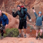
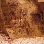
On Saturday, September 8th, the Coalition of American Canyoneers hosted a conservation project at Sundance Canyon in the West Clear Creek Wilderness area of the Coconino National Forest, AZ. Unable to use the CAC’s portable pressure washer within a wilderness area we removed the graffiti the old fashioned way with elbow grease.

A group of twelve awesome volunteers hiked into […]

2018-12-17T16:16:42-08:00September 15th, 2018|Categories: Access, Conservation, General News|Tags: , , , |

Waterholes Canyon Update

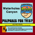
Waterholes Canyon is located on the Navajo Reservation near Page, AZ. The slot is in Navajo sandstone and the lower canyon is popular for having many beautiful features including classic tight twisty narrows, potholes, and a beautiful 320′ rappel down a patinaed wall. As an added bonus, Waterholes Canyon ends at the Colorado River in Glen Canyon National Recreation Area 3-1/2 miles […]

2018-12-17T16:06:47-08:00August 22nd, 2018|Categories: Access, General News, Newsletter|Tags: , , |

Grand Canyon Packraft Rules – Update

packraft
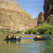
The packrafting rules in Grand Canyon National Park have been overhauled in response to a Coalition of American Canyoneers request early last year. The prior rule required “walking the river bank when possible” and that led to a lot of confusion about which routes were possible and/or acceptable. The new rules eliminate the “walk when you can” rule and extend the packraft […]

2018-12-18T12:21:33-08:00January 12th, 2018|Categories: Access, General News, Newsletter|Tags: , , , |

Cassidy Arch Canyon – New Anchor

new first rappel

Capitol Reef National Park

The Coalition of American Canyoneers was asked by Capitol Reef National Park to consult on anchors in Cassidy Arch Canyon. This canyon has seen a tremendous increase in canyoneering activity over the past couple of years. The traditional first anchor was off of a tree above the arch on canyon left. The tree is showing signs of […]

2018-12-16T13:35:09-08:00July 18th, 2016|Categories: Access, Conservation, Education, Safety|Tags: , , |

Capitol Reef

Introduction:

Capitol Reef National Park encompasses nearly a quarter million acres of slickrock and mixed desert terrain over a 100 mile long expanse called the Waterpocket Fold. The monocline layers through which many of the parks canyons travel provide the canyoneer with a unique opportunity to encounter geology in reverse. Elsewhere, canyons in Capitol Reef are a showcase of majestic, soaring red Wingate walls, with their characteristic cracked and pocketed erosional […]

2023-01-11T17:02:30-08:00June 6th, 2015|

Newsletter – Fall 2014

canyoneers
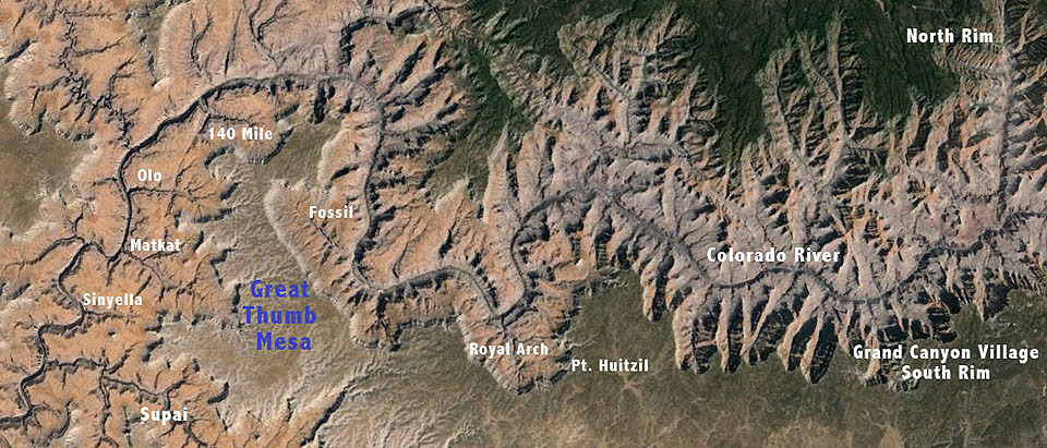
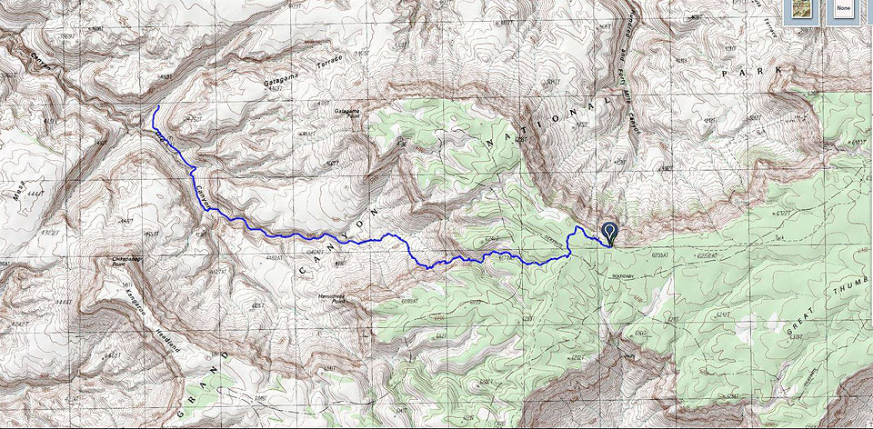
The Coalition of American Canyoneers (CAC) continues to grow, with membership more than doubling this year. We now have over 850 members! Thanks to all of you for joining and welcome to our new members! When dealing with issues like the Eaton Canyon closure in Southern California, or the recent winter shutdown of Kelly Point access in Grand Canyon, the power of […]

2018-12-23T20:12:44-08:00December 4th, 2014|Categories: Access, Conservation, Education, General News, Newsletter|Tags: , |

Dump Truck Canyon

great thumb mesa

Dump Truck – an unpublished slot under Great Thumb Mesa

Another unpublished canyon in the Matkat system is one we named Dump Truck. It’s the east Sinyella Fault arm of the big east tributary arm of Matkat. It was named Dump Truck because the exit was so huge spilling out into the east arm of Matkat in […]

2020-06-19T20:45:18-07:00January 19th, 2014|Tags: , |

Panameta Canyon

great thumb mesa

Panameta Canyon – a tributary to Matkatamiba

If Olo Canyon is the crown jewel under Great Thumb Mesa, then Panameta Canyon might be considered the Hope Diamond. It has some of the prettiest and tightest Redwall narrows anywhere in Grand Canyon with fluting similar to that seen in some softer rock sandstone slots.

The Colorado Plateau is filled with slot canyons. The […]

2020-06-19T20:40:06-07:00January 6th, 2014|Tags: , |

Great Thumb Mesa • History and Summary

Great Thumb Mesa • Grand Canyon National Park

History

Great Thumb Mesa carves a 20 mile arc north into Grand Canyon. It originates on the South Rim about 20 miles northwest of Grand Canyon village. Royal Arch Creek (AKA Elves Chasm) is on the far east side at river mile 118 and Havasu Creek is on the far west side at river mile 157. The Colorado River makes a huge sinuous detour […]

2020-06-19T20:51:56-07:00January 5th, 2014|Tags: , |

LapKat Canyon

great thumb mesa

LapKat – a tributary of Matkat Canyon

Matkat is a big canyon complex tucked deeply into the West side of Great Thumb Mesa. It is the only way to get from the river level to the Esplanade for 20 river miles in either direction. We passed the exit of this slot climbing up Matkat at least six times before I walked […]

2020-06-19T20:37:49-07:00January 1st, 2014|Tags: , |

Matkatamiba Canyon

great thumb mesa

Matkatamiba Canyon

Grand Canyon river runners know Matkatamiba Canyon well (AKA Matkat). More recently, technical canyoneers visit via 150 Mile Canyon. But to backpackers it’s a mystery. How would you get there? The way to Matkat isn’t easy, but the fastest route is off Great Thumb Mesa southeast of Towago Point. No matter how get there, the slot in the Muav […]

2020-06-19T20:37:16-07:00December 23rd, 2013|Tags: , |

Olo Canyon

great thumb mesa

Olo Canyon – Great Thumb’s crown jewel

Who would have thought that this would be the hardest album to put together yet? In 2008 Todd Martin, Brian Alleyne, and Rich Rudow descended Olo Canyon from the top pioneering the beautiful but difficult North Rim approach down 150 Mile and up Matkat, crossing the river by packraft. It was the hardest slot […]

2020-06-19T20:30:14-07:00December 20th, 2013|Tags: , |

SOlo Canyon

solo canyon

SOlo – a marvelous new find under Great Thumb

If the slot we call SOlo is any indication, Grand Canyon might contain a thousand slots. Certainly more than a person could explore in a lifetime. I had a hunch about the Sinyella Fault on the east side as it emptied into Olo Canyon. There is a really fast route to Olo off […]

2020-06-19T20:27:20-07:00December 19th, 2013|Tags: , |

140 Mile Canyon

great thumb mesa

140 Mile Canyon

140 Mile Canyon rests at the northern end of the Great Thumb Mesa. From the rim it casts a deep gash in the Esplanade North into the Colorado River. Any technical canyoneer hears a siren’s call when looking at that magnificent place from the rim. The photo set includes a map that shows the route of the Deer […]

2020-06-19T20:28:00-07:00December 18th, 2013|Tags: , |
Go to Top