Great Thumb Mesa • Grand Canyon National Park
History
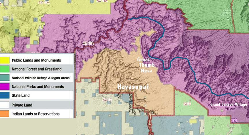
Great Thumb Mesa carves a 20 mile arc north into Grand Canyon. It originates on the South Rim about 20 miles northwest of Grand Canyon village. Royal Arch Creek (AKA Elves Chasm) is on the far east side at river mile 118 and Havasu Creek is on the far west side at river mile 157. The Colorado River makes a huge sinuous detour around Great Thumb Mesa and it’s so large that you can really only see the entire feature from space (1). In ancient times, Great Thumb Mesa was part of the Havasupai homeland that spanned east to Hopi’ lands, south to the current I-40, and west to Hualapai’ lands (2).
In 1882 the Havasupai Tribe was granted a meager reservation consisting of 518 acres inside Havasu Canyon. Throughout the 20th century the Tribe tried to get the US Government to substantially enlarge their reservation lands, during which time the tribe was treated particularly badly by various US Government agencies. On January 3, 1975 President Ford signed Public Law 93-620 substantially enlarging Grand Canyon National Park with the addition of Marble Canyon to the east and western Grand Canyon to the west. This became known as the Grand Canyon Enlargement Act (Law). Part of the Law returned 185,000 acres of Grand Canyon National Park lands, National Monument lands, and Kaibab National Forest lands to the Havasupai Tribe and allowed the tribe to use an additional 95,300 acres of land within Grand Canyon National Park for traditional uses (3).
Most of the repatriated National Park lands were above the rim of Grand Canyon and Great Thumb Mesa was the most prominent feature of lands returned to the Havasupai Tribe. Because the repatriated rim lands were vast and could be used to block public access to Grand Canyon National Park below the rim, the Law specifically required that the public have access to Grand Canyon National Park across the newly repatriated Havasupai reservation (4). The Secretary of the Interior, in consultation with the Tribal Council, was to determine the mechanics for public access. On March 23, 1982 the Bureau of Indian Affairs (BIA) published the final land use plan for the addition to the Havasupai Reservation. Inside that plan were specific actions to provide for public access to the Park across the new Havasupai reservation lands (5) (6).
For nearly 32 years, neither the Secretary of the Interior nor the Havasupai Tribe has executed the plan. Public access across Great Thumb Mesa to Grand Canyon National Park is routinely denied by the Havasupai Tribe. No method to acquire permits has been established. Hikers caught out on Great Thumb are told they are trespassing. The Law has been broken by the Department of Interior and the Havasupai Tribe for 39 years and counting.
Summary
Rich Rudow, board member of the Coalition of American Canyoneers (CAC), participated in the public scoping process for the Grand Canyon Backcountry Management Plan (BCMP) in person on May 25, 2011. Rich submitted detailed written comments in the scoping process on many issues that affect technical canyoneering access. A number of those comments specifically addressed access to the Park across Havasupai Tribal Lands (7).
On December 6, 2013, the CAC Board became aware of a letter from Superintendent David Uberuaga to Tribal Chairman Don Watahomigie seeking to establish 10 permits per year for access across Great Thumb Mesa and seeking to eliminate day hiking north and west of the Pasture Wash area inside National Park lands (8). In response, CAC wrote a letter to the Superintendent requesting a meeting to clarify the access points(9).
Coalition of American Canyoneers members do not support limits on day hike use within the Park and such limits are not part of the Law. Furthermore, CAC believes that 10 permits/year for access across Great Thumb Mesa are insufficient to meet the access requirement Congress defined in the 1975 Law and that any limits on National Park access belong in the upcoming Backcountry Management Plan public process. Access to hiking, backpacking, and ten stunning slot canyons are affected (10).
The CAC Board is currently examining a number of ways to respond to this issue.
References
(1) Great Thumb Mesa Map
(2) “I Am Grand Canyon, The Story of the Havasupai People”, Steven Hirst
(3) Grand Canyon Enlargement Act
(4) Enlarged Havasupai Reservation Boundary Map (below)
(5) 1982 Havasupai Land Use Plan
(6) Havasupai Land Use Plan Map
(7) Rich Rudow’s BCMP scoping process comments • June, 2011
(8) Superintendent’s Letter
(9) Coalition of American Canyoneers’ response letter
(10) Great Thumb Mesa • Photo Series