Introduction:
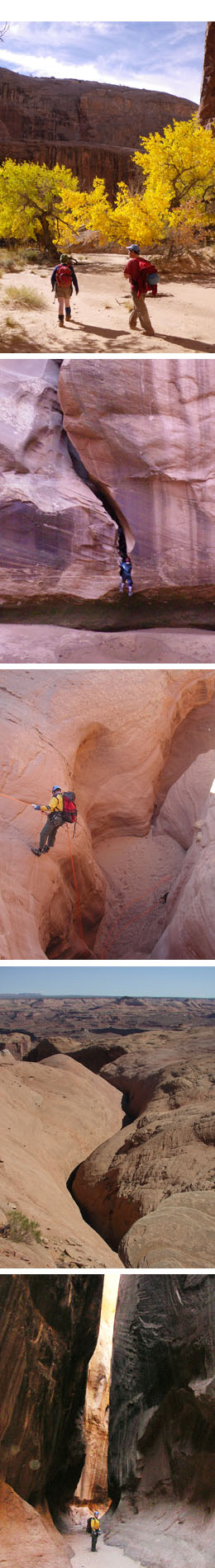
Robbers Roost is remote desert country, where plateau rangeland country is incised by Navajo sandstone slots that release into large, deep canyons. Access to the Roost is challenging, with many miles of dirt road driving required to reach any of the trailheads, and 4WD/HCV capability is recommended. All visitors should come prepared. The closest services of any kind are in Hanksville or Green River. Chances of encountering other users is low, and any kind of emergency response will not be fast considering the remote and isolated nature of the Roost.
The Roost canyon country is best visited in spring or fall, when temperatures are reasonable and access is practical. No permits or fees are required to visit the area, and at-large camping is allowed. The area has a natural anchor ethic, and generally yields easily to such methods, though this may mean using deadmen, cairns, carefully-placed chockstones or other advanced techniques. Use black or natural colored webbing, especially at all final rappels. Please practice leave-no-trace principles to help maintain the wild character of this country.
The flavor of Robbers Roost canyons runs towards the skinny. The options range from classics such as Bluejohn and Larry canyons, to more challenging fare such as Alcatraz (North Fork Twin Corral Box) and Chambers. Squeeze, stem and enjoy, but come prepared as none of these places are within 20 miles of a paved road.
Land Management Resource:
Outside of the small Horseshoe Canyon Unit of the Canyonlands National Park, the BLM Henry Mountains Field Station (Hanksville) manages the Robbers Roost region south of the Wayne/Emery county line. The office is open 7:45am – 4:30pm, Monday through Friday. BLM personnel can answer questions about the land, recent road conditions, etc. All USGS maps of the area are available for sale, as well as a selection of guidebooks.
• 380 South 100 West, Hanksville, UT 84734
• (435) 542-3461
Access Alerts!
None currently.
Rules and Regulations
The information below was obtained from the Hanksville BLM office. Once it is available on the BLM website, a link will be provided.
The Dirty Devil region is designated as a Special Recreation Management Area (SRMA) which means there are certain management objectives for the area. A SRMA plan will be prepared in the coming months to determine the best way to manage the area to meet those objectives. The area is managed for a high probability of experiencing solitude, closeness to nature, self-reliance, challenge, and risk in an unmodified and natural appearing environment with very low interaction or evidence of other users. The Dirty Devil SRMA covers all the canyon areas traditionally associated with the Roost – all drainages entering the Dirty Devil from the north and east, and all drainages of Horseshoe Canyon.
• Both the Dirty Devil drainage and the Horseshoe Canyon drainage are designated as Wilderness Study Areas (WSAs). This means the areas are managed to maintain their wilderness characteristics, meaning no motorized travel, no bolting, no power tools, etc. are permitted.
• Visitors are encouraged to practice leave-no-trace principles.
• For general users, no permits or fees are required to visit the area.
• The only time a permit is required is if the activity is commercial or educational. Contact the Hanksville BLM office for further information.
• Group size in the canyons is limited to a maximum of 12 people for all commercial and organized groups, and there is a recommended maximum of 12 for all others.
Emergency Information:
24-hour Emergency Response: Call 911
Note: Cell phones do not work in many areas of the Roost. Some high spots can get reception from the La Sals / Moab area, and parts of the western Roost can get reception from the Hanksville tower, but it is best not to count on a phone connection.
Emergency services are provided by Wayne County Sheriffs Office Search and Rescue for most of the area; reimbursement of expenses accumulated during any operation is expected.
For Emery County, SAR contact is:
• Emery County Sheriff’s Office – Search & Rescue Team
• 1850 N. Des-Bee-Dove Road. Castle Dale, UT 84513
• (435) 381-2404
Nearest Medical Facilities:
Wayne Community Health Center, located 56 miles west of Hanksville in Bicknell.
• 128 N 300 W Bicknell, UT 84715
• (435) 425-3744
• Hours: The center is closed on Sundays and hours are limited on Saturday.
• The Wayne CHC opens a clinic in Hanksville each Wednesday.
• Directions from Hanksville
Green River Medical Center, located 57 miles north of Hanksville.
• 585 W Main St, Green River, UT 84525
• (435) 564-3434
• Directions from Hanksville
Closest Hospitals are located in Richfield (111 miles west, 2+ hours from Hanksville), Price (114 miles north, 2 hours), and Moab (108 miles east, just under 2 hours).
Richfield:
Sevier Valley Medical Center (Intermountain)
• 1000 North Main, Richfield, UT 84701
• (435)893-4100
• Directions from Hanksville
Price:
Castleview Hospital (Intermountain)
• 300 Hospital Drive, Price, UT 84501
• (435) 637-4800
• Directions from Hanksville
Moab:
Moab Regional Hospital
• 450 West Williams Way, Moab Utah, 84532
• (435) 719-3500
• Directions from Hanksville
Photos: John Diener