Introduction:
The Grand Staircase-Escalante region was one of the last areas in the United States to be successfully explored. The rugged nature of the geology confounded early attempts to navigate this land, a seemingly endless labyrinth of cracks and canyons stretching as far as the eyes could see. What was a beautiful, but disheartening sight to the early traveler is now seen with eager eyes by a new generation of explorers.
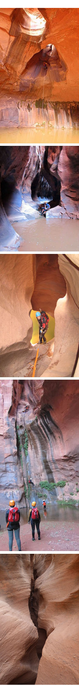
The variety and number of canyons in Escalante is staggering. There are a few soft and gentle beginner canyons to warm up with, a massive number of intermediate terrain to hone your skills on, then advanced canyoneering until your head and heart are content. There are squeezes, swims, slides, massive rappels, keeper potholes…everything! These are definitely “working canyons,” with loads of down-climbing, problem solving, and partner assists. Gentle strolls between rappels are a rarity here.
The Canyons primarily cut thru the Navajo and Wingate sandstones, though some beautiful Entrada slots do exist. The Navajo slots are generally quite narrow and physically challenging. You may squeeze, slide, and rappel your way through an endless stone crevasse as one scenic twist melts into the next. Short swims and keeper potholes are common in this formation too. The Wingate slots can be quite narrow, often forming long hallways and “doorways” to squeeze through and around. These canyons regularly hold water weeks after storms pass and long swims in very cold temperatures are not uncommon. Plan on extra neoprene even in the middle of summer. The Entrada slots are generally shorter, wider, and sweet. Hard to find too! Good luck.
Come Prepared:
The incredible isolation associated with the area still exists today, so it is very important (when isn’t it) to come to Escalante fully prepared for your adventure. Always carry a good map with you. Access roads and trailhead locations can sometimes be difficult to locate/differentiate. Bring extra water in the vehicle, a good spare tire, and a can of Fix-a-flat may get you, or someone else, out of a pinch. Consider bringing a shovel and tow strap as well. Those “Jumper boxes” with an air pump are pretty cool too.
Travel Plan:
The most common type of SAR conducted in the area is for OVERDUE hikers/canyoneers. The “old timers” in town say everything happens a little slower in Escalante and believe me, it’s true. Because of this, it is best to plan accordingly and allow ample time for your adventure. Gather pertinent information, inquire about road and canyon conditions, estimate your time and add a little extra time to that. It is critical that you communicate the details of your trip with at least one responsible individual. This person should know your travel plan and know who to contact in an emergency, which in this case is Garfield County Sheriff’s Office/SAR: (435) 676-2678.
Communication:
There is now somewhat reliable cell phone service in town and decent service out on the desert. There are cell towers on Navajo Mountain and Boulder Mountain. One or both of these landmarks can generally be seen by climbing to high points on the desert. You typically need to have a visual to have a chance at service. We encourage canyoneers/hikers to bring their cell phones with them in a protected case. During an emergency or just to announce you are overdue, phone communication can be critical. Personal locator beacons (PLB’s) are an excellent way to ensure reliable communication.
Permits and Fees:
Two separate government land agencies manage the vast areas surrounding Escalante. Glen Canyon National Recreation Area (NPS) controls large areas along the Escalante River, from approximately Harris Wash down to Lake Powell. The Bureau of Land Management (BLM) manages the massive Grand Staircase, approximately 1.9 million acres. Permits/regulations are as follows:
BLM/GSENM: No day use permit required. Overnight permits are free and available at the Escalante visitor’s center and major trailheads. BLM/GSENM Permit Information
NPS/GCNRA: No day use permit required. Overnight permits are free, available at major trailheads. There is a 14-day maximum stay.
Regulations:
Canyoneering is currently authorized in Glen Canyon and the Grand Staircase Escalante. Use of natural anchors or existing bolts is highly encouraged and minimum impact travel is essential to protecting these fragile environments. Placing new bolts is illegal. Replacement of unsafe bolts is currently authorized. Future canyoneering opportunities may depend on the initial impacts caused by the sport’s emerging pioneers. Extend webbing to minimize rope grooves, travel in small groups to reduce “social trails”, and follow LNT protocol. Whenever possible, leave it cleaner than you have found it.
Access:
Hole in the Rock Road (HITR) located 5 miles east of Escalante and Burr Trail east of Boulder are the primary roads used for accessing the canyoneering here. HITR is a 57-mile long graded dirt road that ends overlooking Lake Powell. From HITR, many roads lead north toward the Escalante River and the countless canyons found there. Wash board and sandy conditions are generally encountered the entire length, but it does tend to degrade the farther down the road you get. Burr Trail is 77 miles long, with asphalt on the western 25 miles. This road provides access to the Wolverine Loop, with many classic and future classic canyoneering routes to be explored. Burr Trail and the Wolverine loop are not too sandy, but washboard conditions are normal.
Note: Both roads become impassible during and after rain or wet snow. Clay nightmare ahead!
Emergency information:
24 Hour Emergency Response: Dial 911.
Remember – cell service is spotty here. Also be aware your 911 call may be routed through Page, Arizona creating the potential for delay. Knowing the grid coordinates of the location requiring assistance will expedite things considerably. There is a pay phone at the 66 Gas station in Escalante and one at the Hills and Hollow/ Sinclair Gas station in Boulder.
Search and Rescue:
Garfield County Sheriff’s office provides the majority of rescue services. Kane County Sheriff’s office also provides SAR on the lower portion of HITR, although response from Kanab is typically slower.
Garfield County SO/SAR (435) 676-2678
Kane County SO/SAR (435) 644-4916
Medical Helicopter:
Classic Aviation from Page, Arizona provides helicopter response and transport for medical emergencies. Typically County SAR will handle all helicopter resource coordination, however just in case: Phone: (800) 444-9223
Note: This is not a “search” helicopter, it is for medical emergencies. This is a private company and you WILL be charged for services. Also, you must have an exact grid coordinate before they will leave the airport.
Closest Medical Facility:
Ivan Kazan Memorial Clinic
• 65N Center St., Escalante, UT 84726
• (435)-826-4374
• Hours: MWF 10am-3pm. Minimal services available.
Closest Hospitals:
Garfield Memorial Hospital
• 200N 400 E, Panguitch, UT 84759
• (435) 767-8811
• Hours: M-F 9am-5pm. Closed weekends. 24hr Emergency Room available.
Dixie Regional Medical Center
• 1380 E Medical Center Dr., St. George UT, 84790. 24 hr Emergency Room services available.
• (435) 251-1000
Dentist
The Tooth Ranch: Dr. Scott Anderson
• 374 S 300 E, Bicknell UT, 84747
• (435) 425-3391